Kenai Peninsula Alutiiq Place Names, Page 1 Kenai Peninsula Alutiiq Place Names, Page 2 Kenai Peninsula Alutiiq Place Names, Page 3
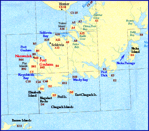
| Location Code | Alutiiq Name | Meaning | English Name |
| K11 | Usuunaat | Has to do with cold | Barren Islands |
| Location Code | Alutiiq Name | Meaning | English Name |
| CI10 | Yaamaaraak | "two small rocks" | Sister's Rocks |
| CI15 | Tangirnaq | "spit" | Homer Spit |
| CI16 | llaraa'alek | "one that has an added (extention)" | Homer |
| CI18 | Cicirpak | (Ser. Moon., Joe T.) | Kachemak Bay |
| Location Code | Alutiiq Name | Meaning | English Name |
| A1 | Nanwaq | "lake" | Halibut Cove (lagoon) Peterson Bay |
| A2 | Cainiim Nunii | "teakettles land" - is is Cainiik a person's name | China Poot Bay |
| A4 | Anisiim Nunii (ST) Anisiim Cingia | "Anisiim's Land" (JT) "Anisiim's Point" | Anisom Point |
| A5 | Anisiim Kangiqulua | "Ansiim's Cove" | Neptune Cove? |
| A15 | Llalliinuuq Tasitnuuq | Sadie Cove, Tutka Bay | |
| A6 | Kenai Atha.name Tahtsitnu | ||
| A8 | Yaakuluum Kangiquluq | "Jakalof Cove" | Jakalof Bay |
| A10 | Arsiintiim Nunii Arsiintiim Tangirnaa | "Arsentie's Land" "Arsentie's Spit" | McDonald Spit |
| A12 | Kasngsaayam Kuiya | "Kangsaayaq's River" Kenai Athabascan name: Angidahtnu | Barabara Creek |
| A13 | Angaakitaqnuuq | Angidahtnu | Seldovia |
| A14 | Nasquruaq | "head like (point)" | Point Naskowhak |
| A16 | Nikraq | Kenai Athabascan name: Nika'a | Yukon Island |
Port Graham Area
Listen to Feona Sawden pronounce the following Sugt'stun place names and discuss their English meaning.
| Location Code | Alutiiq Name | Meaning | English Name |
|
B1 |
Qayarwiq |
"place for boats (kayaks) |
boundary between Port Graham and Seldovia |
|
B2 |
Cingyacungam |
"young sibling" |
4th of July Creek (point) |
| B3 | Cingyacungaq | "smallish point" | Point Pogibshi |
| B4 | Kuikcak | "big river" | Largest of Port Graham Bay rivers |
| B5 | Tuq'aqgwim Cingia | "point of Tuq'aqgwik" | Dangerous Cape |
|
B6 |
Tuq'aqgwik |
"mine" |
Coal Cove |
|
B7 |
Saagtaaq |
"rocks" |
Russian Mine |
|
B8 |
Yaamaat |
|
Bird Reef |
| B9 |
Qikertaawaawam (JT) |
"islands" | Passage Island |
|
B10 |
Qikertaawam Nuutqai |
"Passage Island Reefs" |
|
|
B11 |
Tar'iwik |
"place for making salt" |
(beach) |
|
B12 |
Nanwarnaq |
"lagoon" |
Selenie Lagoon (exact location uncertain) |
|
B13 |
Atqernaq |
"sudden going out to open water" |
possibly isthmus at mouth of Selenie Lagoon |
|
B14 |
Et'ungauq |
"small portage" |
near Atqerhneq on the sandy beach: same as 33 |
|
B15 |
Liivakaa, Liivakaam Qutii, Cingia |
|
uncertain location |
|
B16 |
Waaskaam Qutii |
"Wilie's beach" or Waaskaam Nunii "Willie's land" |
Willie Moonin's across from cannery (DA) |
|
B17 |
Ing'ircaaq |
"way to ascend mountain" |
near 1b (DA) |
|
B18 |
Ing'ikcak or Ing'ircaaq |
"big mountain" |
near 1b (DA) |
|
B19 |
Lugsurwik Qutekcek Inulumuq (DeL) |
"place to get wild chives" long beach (shoreline) |
near 16 and 17 willie's beach and way up mountain Spit and Lagoon by F&G marker |
|
B20 |
Mayurwik |
|
|
|
B21 |
Mayurwim Ingria |
|
Mayurwik Mountain |
|
B22 |
Initaallret |
"old drying racks" |
exact location uncertain |
|
B23 |
Antuun Kuiya, Kia'iwia |
"Tony's beach" or Antuun |
location uncertain by Isle which Antuun? (DA) |
|
B23a |
Alimalenguasaaq |
|
Fred Ukatish's grandfather's mountain |
|
B24 |
Nisllaaq |
|
|
|
B26 |
Kuikcak or Apaasuum Kuiya |
"large creek or Dan Anahonak Creek" |
|
|
B27 |
Nanwanguasaaq |
"small lake" |
|
|
B28 |
Glliiparuaq |
"mountain that looks like bread" "like dinner roles" |
along the Port Graham River above the first big hole |
|
B29 |
Aggtarnaaq |
"Mountain with skin drum" |
location uncertain |
|
B30 |
Watmen Caumaqaq Quta |
"beach that faces out toward bay" |
|
|
B31 |
Morfiim Ingria |
"Murphy's Land" |
|
|
B33 |
Et'unguaq |
"small portage" |
Same as 14 (a second one) |
|
B34 |
Iwanum Qutii |
"John Moonin's beach" |
|
|
B35 |
Amikum Yaami (SM) |
"octopus rocks" "octopus den" |
|
|
B36 |
Ucinguluguam Qutii (SM) or Ucingum Qutii (JT) |
"silly old lady's beach" "old lady's beach" |
|
|
B37 |
Kangiyanguam Cingia |
"Point of Kangiyanguaq" |
|
|
B38 |
Teklegem Namwarnaa or Nanwarnaq |
"Dick Anahonak's lagoon |
|
|
B39 |
Kangiyanguaq |
"small bay" |
|
|
B40 |
Tunkuin Kangiqulua (SM) Tunkuin (JT) |
"Duncun's Cove or Duncun's" |
Duncun Slough |
|
B41 |
Qungut |
"graves" |
|
| B42 | Paluwik | "place to be sad" (perhaps originally place of starvation) | Port Graham |
|
B43 |
Paluwiim Ingria |
"Port Graham Mountain" |
Port Graham Mountain |
|
B44 |
Ilutuqkcin Ingria or Ilutuqanguasagaaq Ingria or Luutuqam Ingria Ilutuqabguasaaq |
"little hollowed-out mountain" "hollowed out mountain" |
|
|
B45 |
Miitriim Cingia Miitriim Nunii |
Demetrie (Moonin's) Point" or Demetrie M.'s Land" |
|
|
B46 |
Taalangaayiim Qutii |
"Taalangaayaks's Beach" |
|
|
B47 |
Sali'ilek |
"Creek Having Shale" |
|
|
B48 |
Laugkaallrem Kuiya |
"Creek of the Old Store" |
|
|
B49 |
Laugkaallrem Qikertaawai |
"Islands of the Old Store" |
|
|
B50 |
Laugkaalleg |
"Old Store" |
|
|
B51 |
Cuquus Cingia |
"Cuquus Point" apparently from the Kenai Atha. c? |
|
|
B52 |
Cuquus Cingia |
|
|
|
B53 |
Cuquus Nagaayui |
"rock islands" |
|
|
B54 |
Agwiillquq |
impassible point |
|
|
B55 |
Qurllaggwik or Qurllurneg |
"waterfall" |
border between Port Graham and English Bay |
|
B56 |
Quikcak |
"large rock bluff" |
|
|
B57 |
Culurlleg or Mayuruutak |
"landing" as at the ladders |
|
|
B58 |
Caqallaqaarsurwik |
"place to get seaweed" |
|
|
B59 |
Qutnguasaaq |
"small beach" |
|
| B60 | Allulek | "(point) having beads" | Russian Point |
|
B61 |
Aneryaaqunguaq |
"small sighing (rock)" |
|
|
B62 |
Agayuim Cingia |
"Church Point" |
|
|
B63 |
Atanenguaq or Nuutqat |
"small fish backbone" or "reefs" |
|
| B64 | Nanwalek or Nuna | "(place) having place or village" | The village used to extend down to the beach or reef. At this time the lagoon was a lake continuing down. Hence, it was called "place having a lake." |
|
B65 |
Nanwaq |
"lake" |
English Bay Lagoon |
|
B66 |
Tangirnaq |
"spit" |
The Spit and English Bay |
|
B67 |
Kui'naq |
"point of the river" |
|
|
B68 |
Nanwalem Mer'a |
"English Bay water" |
small creek dividing English Bay, the source of water supply |
|
B69 |
Nanwalem Ingria |
"English Bay Mountain" |
English Bay Mountain |
|
B70 |
Ququulqiig |
same as 16 "hillside" |
location uncertain, above lagoon on SW side of English Bay |
|
B71 |
Kuik |
"creek" |
English Bay River |
|
B72 |
Qanglluq |
"Hole in River" |
First Hole |
|
B73 |
Qurllurta |
"Waterfall" |
Waterfall or second hole |
|
B74 |
Nanwanguasaaq |
"Small Hole" |
First Lake |
|
B75 |
Nanwakcak |
"large lake" |
Second Lake |
|
B76 |
Nanwakciim Keluqllia |
"the one farther from Nanwakcak" |
Third Lake |
|
B77 |
Qultuucaaq |
|
Fourth Lake |
|
B78 |
Qultuucaam Keluqllia |
"the one farther up from Qaltuusaaq" |
Fifth Lake |
|
B79 |
Perngaqaq Nanwaq |
"bent lake" |
Horseshoe Lake |
|
B80 |
Megnii'inguaq |
"small bald(ish?) hill" |
|
| B81 | Cayiill | Mt. Bede | |
|
B82 |
Agayuut Misngawiat (SM) or Agayuut Sakairturwiat |
"shag's perch" "shag's resting place" |
|
|
B83 |
Nanwalem Cingia |
"English Bay Point" |
|
| B84 | Quglerquik | "place where water comes out" | |
|
B85 |
Luulenguasaaq (JT) Luulek (JT) |
"having wild chives" |
|
|
B86 |
Nalltuliq |
"steel (?) (could also mean (point) even with (85)" |
|
|
B87 |
Nanwalenguasaaq |
"place-having-lake" or Little English Bay |
|
|
B88 |
Nanwalenuasagaam Pehngua |
"Little English Bay Hill" |
|
|
B89 |
Satuut or Satullret |
"weirs" or "old weirs "Fish Trap" |
Note: Qiciisllaam nuni Fred Ukatish's land |
|
B90 |
Enem Cingia |
"house point" |
|
|
B91 |
Qurllurta |
"waterfall" |
|
| B92 | Tuuyarriik | Flat Islands | |
|
B93 |
Carwatuqaq |
"place where the current is strong" |
Pt. Bede |
|
B94 |
Carwatuqam Yaamaa |
"Pt. Bede Rock" |
|
|
B95 |
Carwatuqam Ingria |
"Pt. Bede Mountain" |
|