Channel Changes Slide 3
| 3 of 25 | << First | < Previous | Next > | Last >> | Back to gallery |
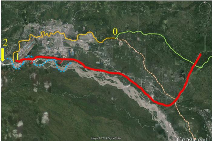
Various locations where clear Chena River and silty Tanana River waters merge.
Notes:
The Tanana River dominates an extensive floodplain from the confluence of the Chena and the Tanana Rivers. We tend to think that the confluence is, and always has been, at the southwest end of the runway/taxiway system at the Fairbanks International Airport (1). That is where silty Tanana River water encountered clear Chena River water for about 60 of Fairbanks’ first 100 years (1949-2009). Until shortly after World War II, however, silt-laden Tanana River water mingled with clear Chena River water at the confluence of what is now called Badger Slough and the Chena River (0). At that time, the upper end of Chena Slough was dammed near Moose Creek Bluff (out of view to the lower right of this image). Since 2010, a new “mouth” of the Chena River (2) is effectively taking form about 1.6 mile (2 km) downstream of its traditional mouth (1).
The sinusoidal Tanana River main channel that used to maintain the traditional mouth of the Chena River was destined to be straightened by a combination of the main dike and the 11 downstream groins added to that dike by the U.S. Army Corps of Engineers south of the Fairbanks Airport as part of the Chena Flood Control Project after the catastrophic Fairbanks flood of 1967.