
Between mouth of Chena River and Byers Island Gallery
Date Observed: Mar 31, 2012
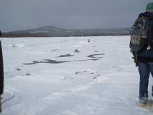 Ice shelf ridge along the main snowmachine trail between the mouth of the Chena River and Byers Island in the middle of the river surrounded by spots of opening water. Processes Observed |
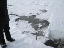
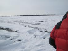 Dangerous area of newly formed patches of open water amidst main snowmachine travel route between the mouth of the Chena River and Byers Island. Processes Observed |
Sam Demientieff talks about a new section on the main trail between the mouth of the Chena River and Byers Island that they have not seen open in previous years. Processes Observed |
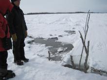 Sticks are used to warn travelers that there is a dangerous ice shelf ridge along the trail between the mouth of the Chena River and Byers Island. Processes Observed |
 It is important to mark dangerous spots to warn fellow travelers, especially ice shelves like this on the trail between the mouth of the Chena River and Byers Island that can be hard to see in poor light conditions. Processes Observed |
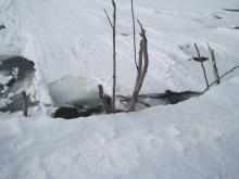
Sam Demientieff tests the depth of the water at this location between the mouth of the Chena River and Byers Island, and discusses the current and the location of the river's main and side channels. Processes Observed |
 Open water and ice drop-off right along the main trail between the mouth of the Chena River and Byers Island. Processes Observed |
Sam Demientieff, William Schneider and Neil Scannell discuss the dangers of traveling when there is a high ice shelf along the trail caused by dropping water and ice levels, like seen here on the trail between the mouth of the Chena River and Byers Island. Processes Observed |


