
Middle of Tanana River between Byers Island and mouth of Chena River Gallery
Date Observed: Feb 12, 2010
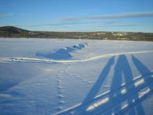 Looking downriver from a spot in the former main channel of the Tanana River, between Byers Island and the mouth of the Chena River. As the channel has changed, water levels have dropped and left exposed sandbars. Behind sandbars, you can observe these drops in water level that cause the ice to collapse. Processes Observed |
While standing in the middle of the Tanana River between Byers Island and the mouth of the Chena River, Sam Demientieff talks about seasonal river channel changes, and how this effects winter ice conditions. He explains "low flow erosion" where the riverbank is undercut beneath the ice. Processes Observed |
Whiles standing in the middle of the Tanana River between Byers Island and the mouth of the Chena River, Sam Demientieff talks about the effect of ice jams on the routing of the Tanana River channels. Processes Observed |

