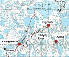
Cungartuli Map
Description:
Map of the winter trail from Cungartuli and Pugcenar to the Yukon River.
Photo By:
Base map compiled by Robert Drozda and Vernon Chimegalrea from information provided by Lower Kuskokwim Yup’ik elders in 1988.
Photo Collection:
AHP CPSU and ANCSA 14(h)(1) Historical and Cemetery Sites Collection [ANCSA Project], Bureau of Indian Affairs, Anchorage, Alaska