
Main trail near Sam Charley Island Gallery
Date Observed: Jan 9, 2006
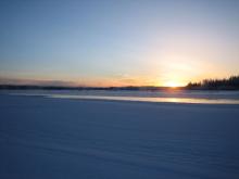 Photo Credits:
Knut Kielland Open water on the Tanana River below Hotcake Slough. Sam Charley Island is visible on the right. The following pictures were taken two days after Knut Kielland initially ran across this unusual area of open water. Processes Observed |
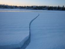 Photo Credits:
Knut Kielland Two-day old crack near Sam Charley Island that was refrozen after really cold temperatures. Processes Observed |
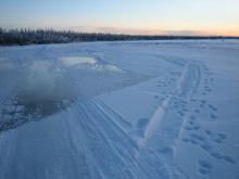 Photo Credits:
Knut Kielland Open water and dangerous ice area that Knut Kielland suddenly came upon when traveling near Sam Charley Island on the Tanana River by dog team. Knut has spent over 15 years traveling the river and has never seen these conditions at this spot. This time, however, the ice was eroded with spots of water bubbling up. The area in the upper right of the photo was "really dicey and scary" with a lot of open water and eroded ice. Once beyond that spot the ice was solid. As seen in this picture two days later, everything was refrozen and safer for traveling. Knut saw no evidence of why it became open water. He speculates that the presence of a sand bar could be a factor, but found no evidence of a bar. He has seen something like this at a spot near the Bonzana Creek Landing at the west end of Seven Mile Island. Processes Observed |
 Photo Credits:
Knut Kielland Knut Kielland measured the ice in this two-day old refrozen crack near Sam Charley Island to be 2 inches thick. Processes Observed |
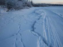 Photo Credits:
Knut Kielland The main trail near Sam Charley Island going downstream, looking southeast, approaching the open water spot. Knut Kielland came upon the spot fast and was surprised because he knows that normally there is no open water there. He had to quickly manuever his dog team to the right to avoid the water. Processes Observed |