Project Jukebox Survey
Help us redesign the Project Jukebox website by taking a very short survey!

Sam Demientieff, Interview 2

Sam Demientieff spoke at the annual meeting of the "Observing Locally, Connecting Globally" teacher education project (OLCG) on December 6-7, 2003 in Fairbanks, Alaska. The theme of the meeting was snow and ice. In this presentation, Sam talks about different types of ice found on the rivers of interior Alaska, the characteristics and formation of each type, and how to determine if the ice is safe. He also talks about his observations of changes in the river ice, the seasons of freeze-up and break-up, and ice jams and flooding, and general climate and environmental changes.
Digital Asset Information
Archive #: Oral History 2001-113-12
Project: Climate Change
Date of Interview: Dec 6, 2003
Narrator(s): Sam Demientieff
Location of Interview:
Funding Partners:
National Aeronautics and Space Administration (NASA), National Science Foundation
Alternate Transcripts
There is no alternate transcript for this interview.
After clicking play, click on a section to navigate the audio or video clip.
Sections
Introduction
Types of Ice
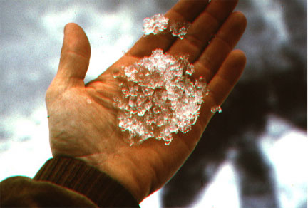
Slide 1: Frazil Ice and Slush Ice Click here for image.
Slide 2: Frazil Pans Click here for image.
Slide 3: Anchor Ice Click here for image.
Slide 4: Dirty Anchor Ice Click here for image.
Slide 5: More Anchor Ice Click here for image.
Slide 6: Jumbled Anchor Ice Click here for image.
Slide 7: Boat and Anchor Ice Click here for image.
Slide 8: Bank Ice Click here for image.
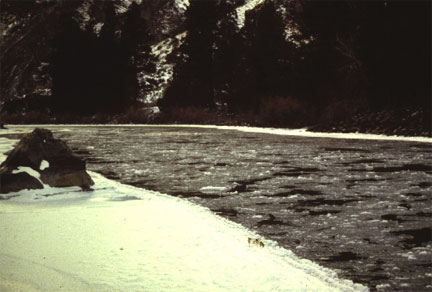
Slide 9: Sheet Ice Click here for image.
Slide 10: Candle Ice Click here for image.
Slide 11: River Freeze-Up Click here for image.
Slide 12: Break-Up Jumbled Ice Click here for image.
Slide 13: Shear Walls of Ice Click here for image.
Slide 14: Ice Dynamics on the Kuskokwim River Click here for image.
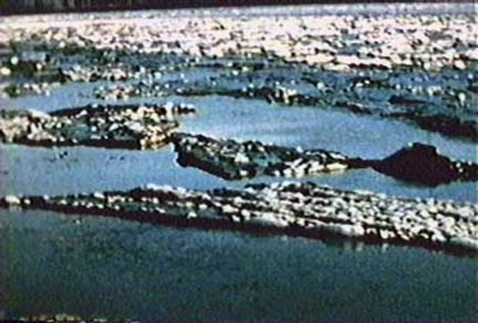
Slide 15: Ice Jam on the Kuskokwim River Click here for image.
Slide 16: Ice Sheet on the Kuskokwim River Click here for image.
Break-Up in Fairbanks
Ice Awareness
Tanana River
Audience Questions
Click play, then use Sections or Transcript to navigate the interview.
After clicking play, click a section of the transcript to navigate the audio or video clip.
Transcript
Samuel Demientieff: What I would like to do, first of all, is just introduce myself and explain a little bit about where I come from and where I lived and the different rivers and -- and lakes and streams that I’ve been on, and the different things that we did in my -- on my dad’s barges when we operated the boats and barges during the ‘40s, ‘50s, and ‘60s. I was born in Holy Cross on the Yukon River, the Lower Yukon River. Left in -- left Holy Cross 1943 when I was about three, four years old. Came to Fairbanks by boat up the Yukon River, Tanana River, up the Chena River to Fairbanks. We lived here in Fairbanks down by Fairbanks -- if anyone here knows Fairbanks, you know where Ron’s Service Station is down on Wendell Street, we lived right in that area. We hauled water from the Chena River to -- for drinking. We mushed dogs on the Chena River. We left here 19 -- actually, every season in the springtime we would leave and travel down the Chena, Tanana Rivers, down the Yukon Rivers, and then haul freight from primarily Nenana downriver to right to the mouth of the Yukon River. And then our main run was from Nenana hauling freight that came up the railroad from the horn of Nenana down the Tanana River to Galena, which is an Air Force Base. But we hauled freight to up the Iditarod River, the Innoko Rivers, the Koyukuk River, the Alatna River, up off the Koyukuk, and pretty much all the tributaries off the Yukon River. So in our -- in our boat and barge operations, we would leave Fairbanks and -- and Nenana early in the springtime, right after the ice broke up. So on the way downriver, we would be able to see ice along the banks of the river that was put there by either high water or floods. And so you would see these big, big, huge 6 foot or 7 foot cakes of ice up on -- way up on the riverbank or all along the riversides, different places. And we were able to see all different kinds and types and structure of ice. You know, when I think back to it now, when I was a kid, I really didn’t see -- because we see them every day, it’s just an -- an ordinary thing. I mean, every season. When I think about it now, I remember the layers of ice, the different strata in the ice composition itself, and was able to see what is called anchor ice. And early in the fall time, I think back in the fall time, able to see the different ice when it’s forming, slush ice, what we called was glass ice. And sheet ice. And then just what are called cans of ice, just big, round ice cakes. The -- so in the springtime, when we were going downriver, we are able to see areas of the Tanana -- primarily the Tanana and the Yukon Rivers where the ice jammed at certain bottlenecks in the river, and the ice pushed up onto the riverbanks and gouged out -- uprooted trees and pushed the riverbanks up. And so during those time periods, and I’m talking about the ‘40s, ‘50s, and ‘60s, right up to the early ‘70s, it was always predictable. It was always easy to see that during those time periods, we would encounter a regular winter. A regular winter in those days where it was -- where the freeze-up would occur sometimes in the middle to late October, and then freeze over in November, and then you’d be into winter and are able to use the river -- rivers, lakes, and streams. And during the winter, there was always a time period where I remember the KFAR radio announcers calling them cold spells. And the cold spells were when, here in Fairbanks, the temperature dropped down to 30 below zero and for the high during the daytime, and 40 to 45 below zero during the evening. And that would last anywhere from 7 days to 10 days, two weeks, and sometimes up to three weeks. But the average was between 10 days and two weeks. That was called a cold spell. After that cold spell occurred, which was sometimes during December and January and into February, there would be cold snaps. And the weather people would call the cold snaps one to three days where it dropped down to -- once again, to 30 to 40 below zero, and then -- then the cold snap was 40 to 50 and 60 below zero. So these cool spells will -- would run 40 to 50 to 60 below zero. And if you looked at weather records, you could see in different villages in the Interior where the temperature actually dropped down to the 70s and 80s below zero. So, but I think about the winters today and people ask me about global warming, or what I think about it, it’s easy to see. I could just look at last year, for instance, 2002. Here in Fairbanks, the temperature got to 40 below zero one day. And that was it. So when they ask me about weather changes, I say, yeah, it’s easy to see. You know, in 30 years, 40 years, I’ve seen anywhere drops from -- winters have changed dramatically. Now, that’s not a story, that’s just an actual fact of what -- what I’ve seen in my lifetime up until today. And last January in Fairbanks here, it -- it rained. And I’ve never, ever seen it rain in January. But it rained here in the Fairbanks area. And it crust over and it was real slippery conditions. It rained enough where the streams up around the Chena and Tanana Rivers produced enough water to raise the ice in the river and cause flooding along the edges, overflow, and places on the Tanana River where the water came up above the ice level into the snow cover, and made slush right out of all the snow and water mixed together. Now, when that freezes, you have a different composition of ice. It has more oxygen in it, I believe. And that’s when you can see this different strata of ice when you’re way down in the springtime. What we seen was this -- this clear ice, which is a -- anywhere from 1 to 2 feet thick on the bottom, and then different layers of ice as you -- as you proceed the -- winter proceeding and the overflow is taking place. So I just wanted to give you a little background of what occurred and what we’ve seen. And what I’d like to do now is just go to these pictures to show you just some examples of ice conditions as we see -- picked them up off the Internet.
Samuel Demientieff: These are the terms that I told Sidney that we refer to. The bank ice is just ice that forms early in the fall time along the edges. And if you think back to the fall days that you’ve seen along the rivers that you’ve been on or the lakes or streams or creeks, it depends on the currents of the river how much that bank ice forms. Now, what we see in the -- during the ‘50s, ‘60s, ‘70s was when the bank -- bank ice formed, all that is just this ice that’s this thin sheet of ice that freeze along the riverbank. And on the south side of the river, underneath the shade of the trees where the sun does not shine, that ice forms there more than it does on the north side where the sun hits the -- the bank of the river. So you see this -- this bank ice. And then the new ice, all that is is the thin ice that forms on the edges. And the glass ice is the ice -- that same ice that throughout the day, as it warms up, would melt along the edges, and that ice would float out into the river or stream and then float downriver. Now, the reason why this concerned us in our boat operations was because our boats and barges were made out of wood. This -- this ice that we referred to as glass ice looks just like sheets of panes of clear glass that you see anywhere, this glass that you see here. It’s just a real thin piece of ice, half inch thick, right down to a real razor edge sharp edge on the outside. This ice would be floating down the channels of the river and it would cut right into the level -- water level of the barge. So you’d see this glass ice coming down, hitting the wood, edges of our boats and barges and it would cut right through. It could cut right through the paint and into the wood. So it was really critical that we know when this ice is forming and when it’s coming downriver. You’d see it in the water, and if it’s slack water and slow current, you can’t hardly see that ice until you run into it. So this is the terms that we used on the river. These are not really technical terms that the ice scientists and other people have come up with.
Slide 1: FRAZIL OR SLUSH ICE: Click here for image. These are frazil pans. It’s kind of hard to see, but this is the edge of the stream here, and the ice is coming down in just a -- accumulated groupings or chunks. This would be the slush ice out here, the frazil pans -- frazil ice and pans out there. And this is the edge of the river. If you notice the soil on this edge here, this is the shear of the channel. So you have the bank ice here that’s frozen, this is the bank ice here, and right along here is the shear. And this will keep on freezing out to the area where the channel is, the current of the water is coming down and stop right there. And that’s where the ice will keep on flowing until you come to -- it comes to a bend or a place in the river where the gradient is less steep. And the ice will freeze all the way across -- the water will freeze all the way across the river, and then you form a natural jam, then this frazil ice or slush ice will accumulate above it. And if you have a slow-moving river like the Chena or Kantishna or the Melozi or Tozitna that flow into the Yukon Rivers, or the Tolovana River, those rivers -- those rivers the ice would form in a different way. It just forms more smooth. Now, in this -- a stream like this or a river like the Tanana River, the more current you have when you run across those natural jams, the ice coming down in sheets are 1 or 2 inches thick would run up on top the ice and then cause what’s called jumbled ice.
Slide 2: FRAZIL PANS: Click here for image. These are frazil pans. It’s kind of hard to see, but this is the edge of the stream here, and the ice is coming down in just a -- accumulated groupings or chunks. This would be the slush ice out here, the frazil pans -- frazil ice and pans out there. And this is the edge of the river. If you notice the soil on this edge here, this is the shear of the channel. So you have the bank ice here that’s frozen, this is the bank ice here, and right along here is the shear. And this will keep on freezing out to the area where the channel is, the current of the water is coming down and stop right there. And that’s where the ice will keep on flowing until you come to -- it comes to a bend or a place in the river where the gradient is less steep. And the ice will freeze all the way across -- the water will freeze all the way across the river, and then you form a natural jam, then this frazil ice or slush ice will accumulate above it. And if you have a slow-moving river like the Chena or Kantishna or the Melozi or Tozitna that flow into the Yukon Rivers, or the Tolovana River, those rivers -- those rivers the ice would form in a different way. It just forms more smooth. Now, in this -- a stream like this or a river like the Tanana River, the more current you have when you run across those natural jams, the ice coming down in sheets are 1 or 2 inches thick would run up on top the ice and then cause what’s called jumbled ice.
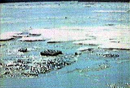
Slide 3: ANCHOR ICE: Click here for image. Samuel Demientieff: Now, anchor ice is ice that forms, and I -- this is a picture of, I think, a lake. And this -- you can see this green areas, these ice -- these areas underneath here are ice that’s forming on the bottom of -- of the either the gravel pit or the lake. Anchor ice, and we’ll see pictures of that in -- in the coming slides, but what we see, anchor ice is ice that is forming along the edges of the river, freezing to the bottom, and that slack water’s on the sides, and then staying there, froze right to the ground. Now, during the winter as you encounter warming periods, you have warm periods and cold periods throughout the winter, and some places they call the warm-up times, chinook, chinook days, and that’s where the temperature really rises real high for a few days and then drops way down. During that temperature rise, the waters in the springs and the water in the river raises. Now, normally you think that ice freezing on a river would just stay that certain level all winter long, but it does not. And that -- when those -- when we encounter those warm days, water in the Chena, I can -- and I see this every day, as the temperature goes up, you can see the water level on the Chena River, initially when it freezes all the way across, it’s just flat. So as you encounter these warm days, the center ice will float on top of the river and it will raise up and you’ll see a bulge on the river. Now, this will stay that way as long as the ice does not crack alongside the edges. As soon as that cracks along the edges from the water, the bulge in the ice, then you have the overflows along the edges. And that’s why the overflows only occur primarily along the edges of the river. And then once that happens, you have this water along the edge, the ice in the middle of the river is staying to whatever thickness it is. If it’s 6 inches thick, it stays 6 inches. Along the edges of the overflow, it increases from 6 inches to 8 inches to 10 inches, when it’s stuck and frozen to the bank of the river on the side. Now, as that occurs all winter long and you have this continuous raising and freezing of the overflows, and this accumulating snow that’s either being mixed with water and becoming this slush and then it’s a different type of structure of ice, then you have -- then the anchor ice will -- when it -- when the river breaks up in the springtime, that anchor ice is still frozen to the banks. You know, the river will raise up, break up, ice is going down, and anchor ice is frozen to the ground and it will stay there, even though it is covered over with water. Now, one of the reasons for my talk here, mainly one of the reasons is to indicate to people that -- how to see different things in ice for safety reasons. Now, anchor ice can be dangerous because early in the spring when the people in the villages go out with their -- their canoes or kayaks to go out hunting, they’re on the rivers, and when they go along the bank of the river, along the edge of the river, that anchor ice can break loose and float up to the top, which you can just -- and actually, I’ve seen it in a canoe myself come up off the bottom. You’ll be sitting there looking for rats hunting in the springtime and it will be real quiet out there, and you’re -- all of a sudden you hear this noise, and you don’t see nothing wrong, and then all you see is the water. It will come up and it’s just a big, huge chunk of -- of this anchor ice that’s frozen to the bottom that floats up later on. Go to the next one.
Slide 4: ANCHOR ICE -- RIVER: Click here for image. Samuel Demientieff: Now, this is -- this is a picture, it’s hard to see, but this is the regular snow and ice here. This dark area right here, right here, and right here is anchor ice. These are -- this is anchor ice that has the -- either the mud that’s froze to the bottom of the ice, you can see it when it comes up off the -- on these ice jams, or it’s ice that’s -- that anchor ice that’s right along the edge that’s pushed up into the riverbank and accumulates mud and dirt on top of it. So this anchor ice and this ice that’s right close to the river edges has mud and dirt on the bottom frozen to it, and mud and dirt on the top of it, and therefore, it does not float like it normally would, it -- it goes up and down in the current of the river. Instead of floating on top, it can go down and hit along the bottom. And so that anchor ice can -- when it comes to a jam in the river, it can cause further damming of the ice. And a lot -- we don’t see that from the surface, but that’s just happening. Get a piece of anchor ice that’s coming down, it comes up and hits the jam, and covers off the bottom section while the current of the river’s hitting. Go to the next one.
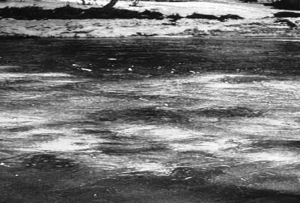
Slide 5: ANCHOR ICE -- RIVER: Click here for image. Samuel Demientieff: This is more of the anchor ice. You can see a piece of anchor -- ice here on top, another sheet of ice here. This is the main river ice out here. This is the edge of the river where the river’s water flowing along the -- the riverbank.
Slide 6: Click here for image. ANCHOR ICE: Samuel Demientieff: This is another piece of -- this is the main river out here, and you can see some of the jumbledness in the river there from the breakup and the subsequent sheets of ice coming down and accumulating. You can see some of that anchor ice out there sticking up there and along the riverbank here.
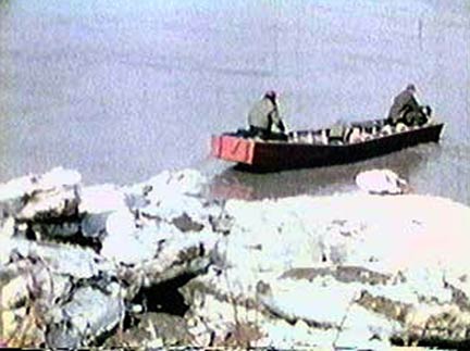
Slide 7: ANCHOR ICE: Click here for image. Samuel Demientieff: Here’s more of that anchor ice here. This -- this is the riverbank here. Here’s a boat, some people are going out in the springtime. And this is the -- the dark colors, the mud and dirt accumulated on the -- on the bottom of the ice and the -- you can see it there.
Slide 8: BORDER OR BANK ICE: Click here for image. Samuel Demientieff: Okay. Here’s more examples of the small stream with the current coming right down the middle and the border or bank ice as they refer to it here. Freezes along the edges where the water is slack, less current, freezes last out in the current area, in the middle of the river.
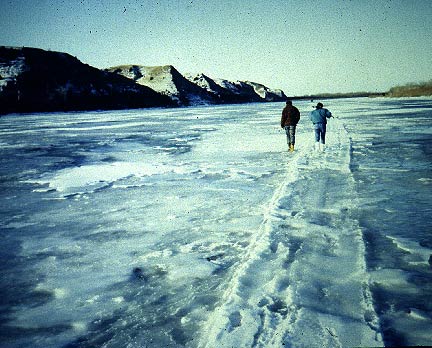
Slide 9: SHEET ICE COVER: Click here for image. Samuel Demientieff: This is a -- what’s called a sheet ice cover. This is -- I’m not sure, but I believe this is the Kuskokwim River. Either that or the Alatna or up the Koyukuk. But you can see the -- there’s hardly any snow cover on this, on the river here. And right here, I think, is a shear channel. It probably -- it probably froze up here on this side first, and then the channel was -- the river just kept flowing down here, and you can see the line right there where that ice kept forming. Now, it’s froze up there, it froze up where there was not much current, and it didn’t have a lot of jumbledness to the ice because there’s not too many cakes floating down there, it just froze smooth. And I -- that’s why I believe this is the -- the Kuskokwim River.
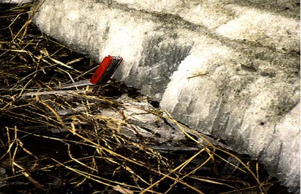
Slide 10: CANDLED OR HONEYCOMBED ICE: Click here for image. Samuel Demientieff: Candled or honeycombed ice, this is ice you see in the springtime. This is a big chunk of 3 to 4 feet of -- I don’t know, this is actually a knife, I think, here. So this is a -- 6 to 8 inches long here, and it’s ice that is the ice on the -- usually the bottom of the river or close to the bottom of the river that freezes, and then when it melts, it has these, like, candles shapes and this honeycombing. And the ice becomes real weak and it starts -- when it breaks up, it has this tinkling sound to it. And it’s real -- if you bump into it, it just kind of shatters down. So that’s the -- the honeycombing of the ice there. So you have different structures in the ice itself.
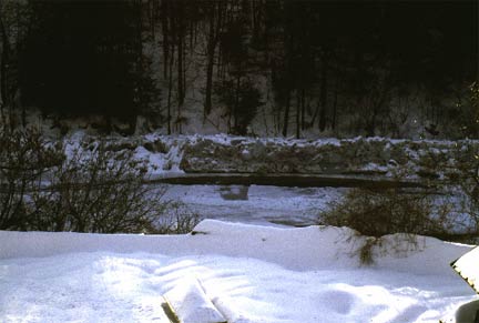
Slide 11: FREEZE-UP JAM: Click here for image. Samuel Demientieff: This is a -- this is a -- a creek that has -- was flowing. Not too much ice accumulating along the bank because the current goes almost right up to the riverbank edge. And as it flowed, it just -- wherever it froze across and jammed further downriver, or when it -- that -- whenever it froze across there, this ice just piles up high and it -- and it just, in this case, it’s just a -- a regular pattern of freeze-up. So when it snows, it will cover that all over and you won’t hardly notice that jumbled ice at all.
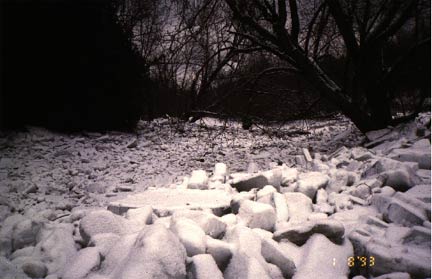
Slide 12: BREAK-UP JAM: Click here for image. Samuel Demientieff: This is more of the same thing in a small stream. I think what happened here was there was a jam, the ice backed up, and then the -- the jam broke and the stream water fell, and you have this ice along -- way up along the edges and the sides here. But you can see how jumbled that ice is there.
Slide 13: SHEAR WALLS (AFTER JAM): Click here for image. Samuel Demientieff: Okay. Here’s the -- I think this is the -- the wall shear for the ice after it broke and fell down. You can see the layer of ice alongside the river there. Then you can actually see some strata in there of how the -- the river or the water flows in different layers because of the temperatures and because of snow on top of the ice. Now, when the snow falls first in the fall time on top of the ice, in the river you have first smooth ice where it -- or jumbled areas, and just all ice itself. When the first snowfalls occur, that weight from the snow -- and it’s hard -- it’s hard to -- you know, you don’t think of this, but that snow -- when it rains, it just goes right in the river in the summertime. And in the wintertime in the fall like this, it’s actually raining, but it’s coming down as snow, and as soon as it accumulates on the river, it has weight. And that weight causes the ice to -- pressure to drop ice a little bit. And as a result of that, it forces water up on the edges so you have this overflow on the sides. So whenever you see it snowing, you’ll always see the weight of the river -- I mean, the ice in the river dropping, being pushed down because the weight of the snow, and you’ll have resulting overflow on the sides, and in some instances, all the way across the river itself.
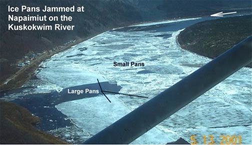
Slide 14: ICE PANS ON THE KUSKOKWIM RIVER: Click here for image. Samuel Demientieff: Okay. This is the Kuskokwim River. And here’s the small pans of ice here. And the large pans of ice right here, the big sheets here. And then the jam down here. And it just causes all this ice to accumulate from the back there.
Slide 15: ICE JAM ON THE KUSKOKWIM RIVER: Click here for image. Samuel Demientieff: Now, on the Yukon River and I think -- I think some places on the Tanana -- on the Kuskokwim, but mainly on the Yukon River, the Lower Yukon, when it -- when the ice jams down there, it’s because of these -- a narrow part of the river and these large pans of ice, large sheets of ice accumulating there, and then causing it to -- the river to rise in the back. You have this anchor ice and other ice that’s jamming and backing the water up. Now, it backs up and the villages all upriver will flood if the water gets high enough. At Holy Cross, we would encounter, in the late ‘40s and early ‘50s, lots of flooding as a result of these breakups like this. And the Air Force was commissioned to come down and do two things. They were either -- they were practicing their bombing, but also helping break up the river ice. So they come down and they went below Holy Cross and the Yukon River, and we could hear them bombing, hear the bombs going off. And they flew back up to Holy Cross, landed at the field there, gassed up, and they were going back out and do some more bombing. And so my dad, of course, came down there and he asked them, well, how is it going? Did you guys get the ice moving? Because it’s flooding the village. They said, no, they didn’t get the ice moving yet, but they are going to go down and continue. He said, well, you -- my dad was -- is a businessman. So what he wants to do is he wants things done now. And he runs that boat and barge operation and things have to be done, they have to be done right, and they have to be done the first time, otherwise you lose money. So he approaches this colonel in the Army there and told him, you should go down there with one bomb, drop it in one place on that river, and the ice should just all go out. It’s just like flushing, flushing the toilet in the bathroom, it just goes up. So the colonel told him, well, do you know where to bomb the ice? And he said, yeah. He said, I can -- you take me down there, I’ll show you where to bomb the ice. So the guy says, come on with us. So they took him down there and he took off and all these people in the village -- in the village waited. I was a kid then. The plane came, the -- I think it was a chopper in this case, came back, and we heard the one bomb blast go off. And they came back and my dad and this colonel after that were real good friends. But this colonel for a number of years was commissioned and came back there every year. And, of course, he would just go straight to Holy Cross and ask for my dad, Nick. He would say, is Nick here? Nick would come out and they would talk a little bit, and they would take off in the air, we’d hear one bomb drop and the ice would go out. So it was interesting to -- to see that. But these jams, there’s critical areas in the river. If you look at where the banks of the river are, the hills, there’s a place on there, right there, if you look where there -- if you know where the channel is, you can see where all the pressure is going to be at a certain place. And if you bomb it right there, for instance, it would crack that chunk of ice and it would go down and everything would move out. It’s just that -- that simple. You know, it just -- it’s not just a -- and it never was always for certain that it would take just one bomb. You know, sometimes they would bomb it and the thing would go down and a big chunk of ice would jam again. So they would have to go down again. But it was usually -- it didn’t take a lot of bombs like they were doing the first time the first few years.
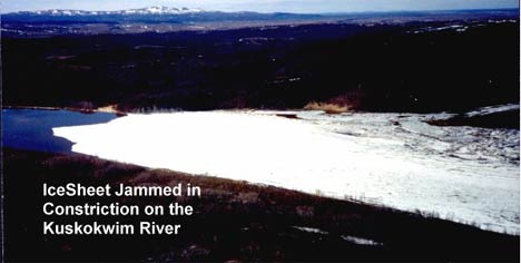
Slide 16: ICE SHEET ON THE KUSKOKWIM RIVER: Click here for image. Samuel Demientieff: Okay. This is an ice jam you can see real easy here on the Kuskokwim River here. This is the upstream side, ice is all jammed here. This is probably a hill there and a hillside here and then a narrow area of the river.
Samuel Demientieff: We look back every week on Sundays, today there will be a -- I think in the Weekender or the insider section of the Sunday paper, you’ll always see a picture of old Fairbanks, a collection from Candy Waugaman’s collection of pictures. And we went through a -- some films in the archives, and we seen on the Chena River lots of activity now. Hockey, ice skating. The Fairbanks winter carnival occurred on the river. Dog mushing. All kinds of activities on the Chena River. We wonder, well, when you see those pictures, why isn’t that taking place now? Well, in the -- I think -- I believe it was the 1950s that they built this -- these power plants down on the Chena River, and the effluent from the power plant is warm or hot water that comes out and is put right into the Chena River. So if you go down there now, when the Chena River does freeze completely over, you’ll always see the river completely frozen over upriver from that water plant. And up to as far as the effluent, I don’t -- I don’t believe that there’s effluent coming from the power plant at Ft. Wainwright, I think it goes to a cooling pond out by Richardson Highway, but still some water’s come -- come from Ft. Wainwright into the Chena River. So there’s two areas where the water is put into the Chena River that’s warm or hot. So all the -- all the river downriver from that water plant is open and it will stay open down as far as the University Avenue bridge. And then from there on down it’s cooled enough where it will freeze solid all the way across the river. So right now I was out there and I snow machined last Sunday and went up, went down to the mouth of the Chena. And here it is, the first part of December, and the Tanana River down -- down at the mouth of the Chena’s still open on this channel, all the way up and down the big bend of the river where normally that river ice would be frozen over in November. So all those activities that you see on the -- in those -- those old pictures of Fairbanks can still occur upriver from the power plant, but most of those activities are moved, of course, onto Second Avenue, you know. But I remember mushing -- I wasn’t a real big dog musher racer or anything like that, but we had dog teams that we ran when we were kids, and I used to run mine from our house or our log cabin on the Chena River up the Chena right to the Cushman Street bridge, tie the dogs up there and walk up to -- go to the movies on Saturday nights or whatever the movies -- whenever we wanted to go to the movies. But we can’t do that now because of that -- the effluent from the water plant. And also, the other thing is, of course, the -- the weather has changed. It’s definitely warmer and the rivers are -- the Chena River will probably stay open for -- who knows, it might stay open all the whole year, but at certain times it freezes over all the way across. When it does freeze over, it freezes quick and it freezes deep. Now, you would think that, okay, since it’s warm, the winters are warmer now than they were in the past, that the ice would be thinner. But if you -- if you watch the breakup at Nenana, you see that ice, you’re still -- still accumulates there and ice thickness is anywhere from 38 to 42 inches thick every year. Now, you wonder, well, why is that? If it’s -- you have warmer winters, why don’t you have thinner ice? And I don’t know the answer to that except that the fact is that ice is still thick. As soon as -- as soon as it starts freezing, it does freeze quick and freezes deep. An average -- same average as older days, on an average. So -- but what is different, in my opinion, is the structure of ice itself. I think -- I believe that the ice is -- is -- has a structure that’s weaker today because of the -- the thawing, freezing, thawing, freezing, and water getting into the snow on top of the ice and causing that -- that freezing to be a different texture and structure and strength.
Samuel Demientieff: Okay. I just wanted to talk a little bit, just a few moments about -- a little bit about how to -- what to look for when you’re going out on the ice, the things to be knowledgeable of so you can go out onto the river ice, mainly the Tanana and Chena Rivers here in Fairbanks -- people around the Fairbanks area. This applies to all rivers. You want to be able to go approach the ice. And remember, the edges of the river are -- are dangerous because you see this overflow. And where initially the ice will freeze flat across the river in the fall time, as when the -- the weather changes, the water raises, and you’ll see a bulge in the ice like this. And so you have this freeze-up -- I mean, water on the edges, the overflow that stays there. Now, you would think that that water along the edges, the overflow, once it gets cold enough, would just freeze uniform. Well, it doesn’t. Because that -- some of the ice along the edges is close to the bottom and it will stay there. You’ll see water on top of the edges, some of the ice will break loose and will float up with the river as it raises. And then as it raises, it freezes on top. And then as it cools off, which it will do, it will cool off, the water in the river drops. And as that drops, you’ll see some of this ice that’s formed that is attached to the bank over here on the higher level will fall down and it will have this area underneath there where there’s an air chamber and a wall of water, running water underneath that ice, and it’s right along the edge. The other day I was going out to the ice to take a look at it and you could see it, you could see it because out there it would be dark, there’s water underneath the ice, there’s no water and it’s likely you could see through it. You can’t actually see through it, it’s just opaque look. So you can’t actually see through it, but you can tell it’s hollow. All you have to do is be aware that there could be water underneath there. I was telling Sidney this that -- and Bill this, that I was down there at my place on the Chena, and the water froze or the river froze over, and it raised up and froze over again, and then dropped. And I was going down there, and it -- it levered up. And so there was a chunk of ice and that come down with my snow machine, and I bump into this 8 inch chunk of ice taken out. So I just went along with an ice pick and was cutting along the edge there. And I was standing out on the -- on the levered area, and I was cutting away, and all of a sudden when I hit it, I was cutting this ice, the ice underneath me cracked. And I just -- I knew it, I knew what to do because the main river ice is right here, just jumped over on that ice. And as it settled down, I look underneath there and see where it’s just water, river water underneath there, and it dropped just enough, 1 foot. So if I stayed on the chunk of ice, I could have slipped into the river there. And if there was current there, like on the Tanana River, I could have just slipped underneath the ice and no one would have really known the difference. No one would have really known anything. So it’s dangerous. On the Chena, it normally probably would not happen because there’s not too much current. So one thing you have to look for is be aware of the sides of the river could be dangerous. On the Tanana River, the -- there’s more current. And along the edges, believe it or not, there is slack water because the current of the river goes out 15 to 20, maybe 30 feet, and it will cause a channel -- a channel in the swift water right along an edge. Now, this slack water right along the riverbank, and the snags and the sweepers that are kind of holding the water steady, the river there will freeze and then freeze quick and thick all the way down. And that’s thick. The anchor ice I was telling you about. But also it’s real safe to walk on. So when we go over there now with our snow machines, we approach the sandbar side, and it’s good all the way out there because that’s frozen right to the ground, right to the ground out to a certain point, then you see this shear. Remember the line in the ice there, the line, you’ll see this shear in the river on both sides. And that’s where you have to be careful of. You see this jumbled ice in there. And the jumbled ice, when it comes down and hits the channel and goes up like this, there’s ice and there’s water percolating and brewing on the downstream side to cause a little steam, and the snow will frost over and cover this area, and you see this raw water will be there all the time. So if what you have to look for when you look at this river ice is these crystals. And sometimes when it’s cold enough and it’s -- you can look at the ice, you can see the little wisps of steam coming up. And those are the areas where there’s just raw water. It could be, you know, 1 or 2 foot in diameter, to maybe 6 feet, and long and skinny. And those areas you have to be aware of. So when you see a jumbled ice, in some cases there’s danger there. So -- but in most cases, 90 percent of the time, 80 percent of the time, it’s safe to go through all that ice. It’s just hard going through because of all the high points and the ice you have to go through.
Samuel Demientieff: On the Tanana River is a peculiar river because there’s a lot of current, like I keep referring to the Tanana and the current there. Even in -- under the water the channels are changing back and forth. And all the middle of the river where the sandbars are, the river where ice would freeze and attach to the sandbar, and just uniformly be -- slope downward. Now, that ice, as it goes out to the deeper areas, you see that lever -- this lens of water underneath there, closer to the sandbar, it’s close enough to the sandbar, but, see, the channel changes out here, it can cut back and cut the sandbar in, all the way in. And as it drops, the water drops, you have this air chamber. And it could be a large air chamber that could be anywhere from 3, 4 inches to 6 inches deep, thick. An air chamber underneath where it eroded close to the sandbar. And that’s dangerous right there when you’re coming down with a snow machine, you can go across the frozen sandbar onto this area and break through, and then you’re right on top of the current that is -- the channel has changed and come right underneath the ice. Now, that’s more of the case for the Tanana River than it is on the rivers. Though I haven’t been on the Kuskokwim or other rivers, but I’m sure that that happens there, too. So this erosion does not -- is not confined to just to the summertime. Now, I talked about this -- the last January, last year where it rained. The -- what we did was went down, and right after that we were trying to go down to Howard -- Howard Luke’s camp on the Tanana. Came down around the bend right across from the Chena Pump campground on the sandbar there, and the river is just all covered with water. So we could not go down there. So we went back and a week or so later it finally dropped down, the temperature dropped down to where it was supposed to be, and the river froze over. And we went down, and this is just completely glare ice, just slick ice all over. The snow that was on top of the ice is now under the ice. And it was really good snow machining, would be good skating. But we went down there, we noticed these two dark humps over in the middle of the river. We went over there and checked them out, and there were two moose that were crossing the river during that freeze-up and broke through the ice. And all we could see was their heads, the side of their heads and ears, and the shoulder because they were -- the rest of the body was all the ways under the ice. So I think that this warm -- this global warming affects not only us, how we use the rivers in the villages and the Interior and all over, it affects animals. I think we see ducks on the Chena River and Tanana River staying more longer into the season than we normally would. Bears come out of their dens earlier. They come out of their dens now where they are not supposed to be out. It’s warmed up and they come out. And what they are looking for is food. And of course, in the wintertime there’s no food. And that’s -- food then equates to any camps that they can raid, any dogs that they come across or other animals. So it’s warming, global warming is affecting animals, too. On the Yukon River, there’s certain areas I believe all over on the different areas that are real swift water areas where there’s a real high gradient of river and the water’s really coming down fast. Those areas are -- will stay open pretty much all winter until it gets to the real severe cold, and then they will freeze across. But those areas in the warming trends like this, I think, would stay open longer. So if you’re knowledgeable of the river and its channels, knowledgeable of these areas in the river where it’s swift water, then you can be alert and operate in safe conditions. So on safety, the things to look for are the riverbank, the hollow areas, the verbled (phonetic) ice and the jumbled ice, and the hollow areas just as we encounter. And what my dad would use and what I still use today is an ice pick. When I’m going across first thing in the fall time, a couple inches of ice can support a person. If you have an ice chart, it helps to -- shows the different weights that could safely accommodate vehicles and snow machines. But you run across that hollow ice, you can hear it real easy. And you have to be aware that -- that the air chamber underneath the ice and the water underneath that water does not freeze, it stays there like that. It will stay there all winter if it doesn’t change in any way. So that’s pretty much my talk. And I’d be happy to answer your questions if you have any questions.
Samuel Demientieff: I’ve fooled you completely, huh? Bill Schneider: Please speak up loudly. MEMBER OF AUDIENCE: Yeah. I come from the East Coast and I don’t know how you would with a lack -- when you have a lack of snow. How did the lack of snow affect the river ice or whatever? Would it have an effect at all compared to previous years? Samuel Demientieff: I believe that it affected the texture and the strength of the ice. But if you look at -- you know, normally you think, well, the less snow on top, the less insulation, and you have deeper ice penetration and freezing. But what discounts that is the ice thickness at Nenana in the springtime. And they broadcast that every -- put that in the newspaper, and you always see that same thickness, 38 inches to 45 inches, in that area. There’s some 3 or 4 feet, and that’s it. And I believe it’s because of the current of the river underneath the ice. I think that less snow on top would -- would naturally -- would presumably mean that’s deeper ice. So I think that there is probably deeper ice, and definitely a different structure of ice. Snow on top of the ice, you know, when you push the ice down, you have this flooding on the sides, but it also insulates the ice. I went down there when this snow occurred here during Thanksgiving. I came back and went out there on the ice and I thought for sure, I seen other snow machine tracks up and down the Chena, and I thought it would be -- there would be no problem. I went out across a couple, headed back and forth, and about the fifth time I went across, I noticed along one of my tracks this dark patch. And so I just -- as I was going by, I see it’s just slush, slush from water that came -- that came up, flooded over the top of the ice in the middle of the river. Now, that -- that’s dangerous in a way that -- first of all, it’s not dangerous, you aren’t going to fall through that slush and get -- and drown because there’s the normal ice that is frozen throughout the fall is still underneath here, and it will hold you up. What’s dangerous is getting wet. Getting wet. And if you’re out trapping or travelling on a snow machine and if you get wet, of course, you’re in trouble, you’ll freeze right away. But normally, it’s not dangerous as far as people panic and think they are going to drown. Well, you can’t drown in that stuff, it’s just a danger of getting wet and freezing. But that stuff will stay there 3 or 4 days and you have to be aware that it’s there. Just be aware -- aware of it. Any other questions? Bill Schneider: Seems to me that you’ve -- you’ve given folks some -- some good stuff to work with, though. I could see if I were a teacher in a village getting some knowledgeable elders together to -- to take some ice picks out and to actually chart what the river looks like in front, and have the kids draw diagrams and the type of ice you’re talking about. And working with the elders, that would be a great exercise, it seems to me, as an outsider. Samuel Demientieff: Okay. Thank you very much. MEMBER OF AUDIENCE: Thanks.