Project Jukebox Survey
Help us redesign the Project Jukebox website by taking a very short survey!

Gil Mull, Interview 2, Part 1

This is a continuation of the interview with Gil Mull in October 2004 with Karen Brewster in Santa Fe, New Mexico. This interview took place on October 21, 2004, day two of the interviewing. This interview began with tape number Oral History 2002-27-22, Parts 1-4, and continues on tape number Oral History 2002-27-23, Part 2. In this part of the interview, Gil talks about doing field work in northern Alaska, the geology of the Brooks Range and the North Slope, and discusses geological maps of the area.
Digital Asset Information
Archive #: Oral History 2002-27-23_PT.1
Project: Gates of the Arctic National Park
Date of Interview: Oct 21, 2004
Narrator(s): Gil Mull
Interviewer(s): Karen Brewster
Location of Interview:
Funding Partners:
National Park Service
Alternate Transcripts
There is no alternate transcript for this interview.
After clicking play, click on a section to navigate the audio or video clip.
Sections
1) Fieldwork in the North Slope, Gates of the Arctic, and Brooks Range area, including field camps, transportation, and type sections
2) The purpose of geological fieldwork, the reasons for park formation, and the affects of oil exploration
3) The role of geology and geological fieldwork, the interpretation of rock units, and the stages of mapping
4) Impressive geological sites in the Brooks Range
5) His favorite geological places in the Gates of the Arctic National Park and in the Arctic National Wildlife Refuge
6) Geological maps for the Brooks Range and the Gates of the Arctic, and how the geological significance of these areas are overlooked
7) The features of a geological map, along with examples and interpretation of those features
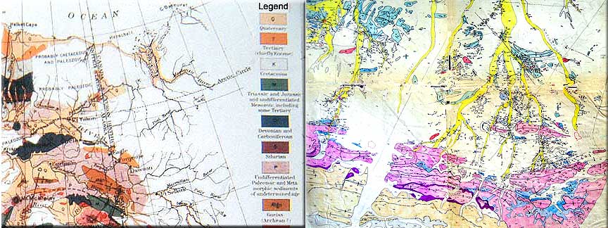
8) What the color legend of a geological map represents, along with examples of geological locations
9) The geology of the North Slope and what the colors on a geological map represent in the Brooks Range, North Slope, and Gates of the Arctic area
10) The importance of rock units in interpreting geological time and geological formations of certain localities
Click play, then use Sections or Transcript to navigate the interview.
After clicking play, click a section of the transcript to navigate the audio or video clip.
Transcript
Section 1: North Slope -- fieldwork\ Brooks Range -- first field season\ Anaktuvuk Pass -- first field season\ Gates of the Arctic -- minimal fieldwork\ fieldwork -- primary locations\ Gates of the Arctic -- broad reconnaissance\ Gates of the Arctic -- second field season\ camp -- location\ Chandler Lake -- camp site\ transportation -- types of\ transportation -- seasonal\ Anaktuvuk Pass -- minimal mapping of\ stratigraphy -- familiarity with\ Mull, Gil -- reconnaissance mapping\ United States Geological Survey -- provided stratigraphic data\ equipment -- uses of\ pilot -- importance of\ summer -- Chandler lake\ Chandler lake -- location of\ lakes -- camping sites\ lakes -- benefits of\ air strips -- none\ gravel bars -- limited availability\ helicopter -- field arrangement\ float\ Killik River drainage -- fieldwork\ Gates of the Arctic -- fieldwork\ Gates of the Arctic -- unlimited restrictions\ mapping -- general process\ mapping -- locations\ Gates of the Arctic -- not a designated park \ Gates of the Arctic -- significant geological locations\ type section -- Lisburne limestone\ Lisburne -- location of\ Lisburne -- importance of\ Lisburne -- characteristics of\ rock units -- exposure of\ type section -- definition of\ type section -- rock unit reference\ type section -- employed by\ type section -- descriptive\ outcrop -- sample of\ Kanayut conglomerate -- description of\ Kanayut River\ Fortress Mountain -- type section\ Castle Mountain -- type section\ Fortress Mountain -- formation description\ Fortress Mountain -- history of\ Castle Mountain -- characteristics\ type section -- geological references|
Section 2: park -- formation of\ park -- non-geological reasons\ dall sheep -- prevalent\ Castle Mountain -- dall sheep\ dall sheep -- reason for park\ Gates of the Arctic -- second field season\ Tukuto Lake\ Howard Pass Quad\ camp -- location of\ field season -- ending of\ Hall, Ed\ Tukuto Lake -- archeological site\ Hall, Ed -- archeological excavation\ Gates of the Arctic -- fieldwork\ fieldwork -- minimal oil exploration\ Gates of the Arctic -- no oil potential\ fieldwork -- purpose of\ fieldwork -- rock interpretation\ high mountain range -- no oil potential|
Section 3: geology -- problem solving\ science -- theoretical\ rock units -- changes in\ Lisburne limestone -- importance of\ Lisburne limestone -- location of\ Lisburne limestone -- characteristics of\ rock units -- interpreting change\ questions -- regarding change\ stratigraphy -- looking for\ rock -- focus on structure\ geology -- researching structural exposures\ mapping -- rock structures\ rock units -- descriptions of\ geological fieldwork -- investigating change\ geological fieldwork -- initial stage\ initial stage -- broad mapping\ frame work -- broad\ questions -- development of\ localities -- specific research\ aerial photos -- uses of\ mapping -- more detailing\ mapping -- necessity of|
Section 4: southern Brooks Range -- reconnaissance mapping of\ reconnaissance mapping -- involved with\ reconnaissance mapping -- locations of\ geology -- significance of\ Mount Igikpak\ Walker Lake\ Arrigetch Peaks\ granite -- plutonic rock\ plutonic rock -- significance of\ plutonic rock -- igneous rock formation\ granite -- historic significance\ rocks -- geological importance\ rock uplift -- differences in\ fieldwork -- geological history\ north Brooks Range -- Mount Doonerak\ Mount Doonerak -- significance of\ geological location -- importance of\ geological concepts -- proven by\ central Brooks Range -- thrust-fault\ north Brooks Range -- origin of\ Mount Doonerak -- geological exposures\ geological exposures -- location of\ geological stratigraphic exposures -- proven results\ geological stratigraphic sequence -- naming of\ geological stratigraphic sequence -- similarities with\ rock sequence -- other\ stratigraphic sequence -- contrasts between\ type section -- not identified as\ geological stratigraphic sequence -- important structural section\ statrographic relationships -- identification of\ Brooks Range -- composition of\ Brooks Range -- relationship between\ Brooks Range -- significant geological locations\ Lower 48 Parks -- geological relationships\ Brooks Range -- not for geological reasons|
Section 5: Gates of the Arctic -- favorite places\ Mount Doonerak\ North Fork Koyukuk\ Bombardment Creek\ Amawk Creek -- geological favorite\ Cockedhat Mountain -- most scenic\ Lisburne limestone\ limestone -- geological characteristics\ Ernie Creek\ Limestack Mountain -- great location\ Arrigetch Peeks -- granite exposures\ Mount Doonerak -- geological significance\ Mount Doonerak -- scenic\ Anaktuvuk Pass\ Gates of the Arctic National Park -- scenic component\ wildlife component\ geological component\ Arctic National Wildlife Refuge -- favorite places\ Ignik Valley -- geological significance\ locations -- geological scientific value\ Mount Michelson\ Mount Chamberlin -- glacial features\ Atigun Gorge -- easy access\ geology -- values of\ geological -- influences|
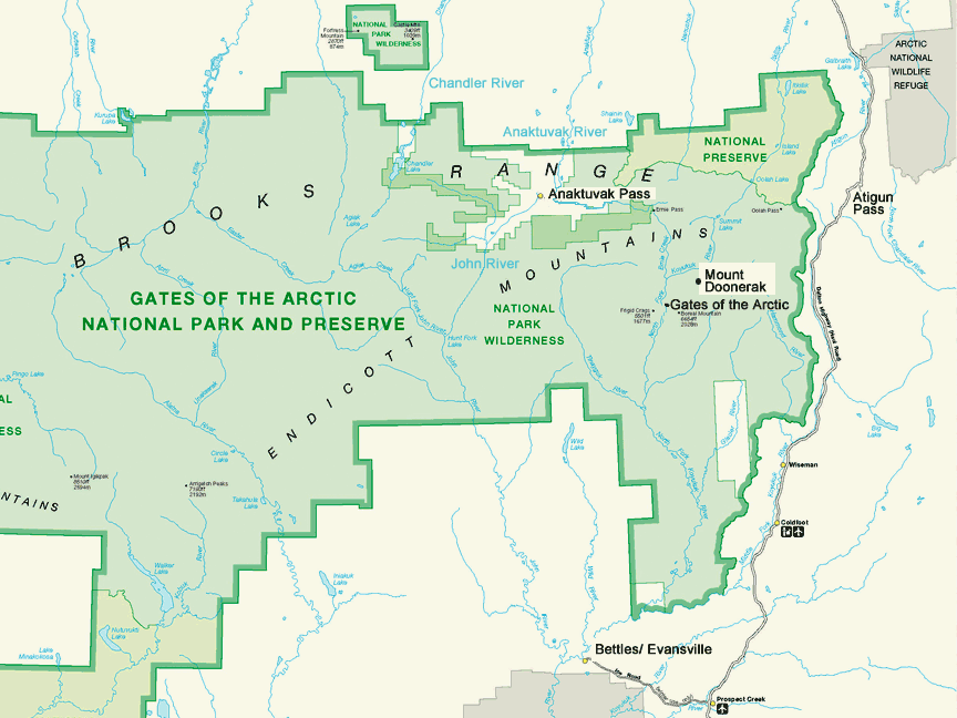
Section 6: maps -- description of\ mapping -- background\ map -- Haul Road area\ map -- development of\ mapping -- process\ map -- rock description\ map -- rock characteristics\ map -- sample of framework\ To view a map related to general locations. Anaktuvuk Pass -- location of\ John River\ To view a map related to the Lisburne limestone structure. Lisburne limestone -- cliff forming rock unit\ Lisburne limestone -- pink on map\ Lisburne limestone -- rock unit characteristics\ rock unit -- area of\ rock unit -- thickness of\ rock unit -- scenic\ Kayak shale -- description of\ Kayak shale -- purple on map\ Kayak shale -- dall sheep\ Lisburne limestone -- historic reference\ Kanayut conglomerate -- underlying Lisburne\ Kanayut conglomerate -- brown on map\ conglomerate -- description of\ history of\ location of\ mountain range -- effects on\ Mount Doonerak -- outcrops\ rock -- description of\ Brooks Range -- erosion history\ Brooks Range -- Devonian period\ conglomerate -- origin of\ mountain range -- length of erosion\ time -- geological terms\ exposures -- significant areas\ geological significance -- not publicly conveyed\ geological features -- ignored|
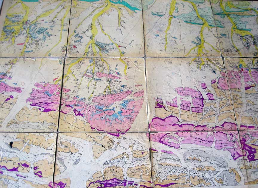
Section 7: To view a map related to this topic. mapping -- colors\ colors -- general guidelines\ colors -- represents rocks\ map colors -- selected by scientists\ pastel color -- large area\ intense color -- specific units\ dark color -- thin bands of rock units\ dark color -- accentuating structure\ kayak shale -- purple color\ contrast colors -- for definition\ Mull, Gil -- visually appealing maps\ colors -- convey aspects\ red color -- igneous rocks\ igneous -- granite\ igneous -- volcano\ intense color -- outcrops\ color -- reasons for|
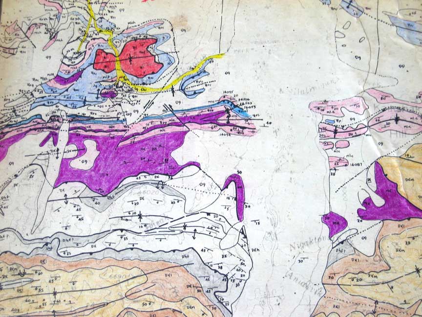
Section 8: To view maps related to this topic. rock layers -- color key representation\ color key -- geological legend\ legend -- vertical representation of rock units\ legend -- color block\ legend -- represent stratigraphic sequence\ mapping -- thrust faulted representation\ thrust faulted -- description of\ thrust faulted -- outcrop area\ thrust faulted -- map location\ Okokmilaga River -- location\ rocks -- brown color\ rocks -- Kanayut conglomerate\ conglomerate -- geological significance\ Lisburne limestone -- pink color\ stratigraphic sequence -- explanation of\ mountain range -- development of \ Kurupa Lake -- mountain description|
Section 9: To view a map related to this topic. yellow -- stream valleys\ stream valley -- significant geological location\ valleys -- alluvial\ valley -- specific locations\ river valley -- specific locations of\ geological map -- purpose of\ northern region -- natural resource recognition\ outcrops -- importance of\ geologists -- focus of outcrops\ North Slope -- importance of\ glaciation -- Brooks Range\ glaciation -- historic reference\ Brooks Range -- effects of glacier flow\ glaciations -- location of\ Killik River -- effects glacial deposits\ Anaktuvuk River -- effects glacial deposits\ Chandler River\ rivers -- listing of\ rivers -- composition of\ composition -- valley glaciers\ glaciations -- process of\ glacial deposits -- newer\ bedrock exposures -- none\ glacial deposits -- effects of\ glacial deposits -- outcrop effects\ outcrops -- not extensive\ bedrock exposures -- locations of\ bedrock exposures -- away from glacial regions\ map -- color green\ green -- represents\ cretaceous rocks -- type of\ cretaceous -- description of\ cretaceous -- historic reference\ cretaceous rocks -- beyond glaciation region\ cretaceous rocks -- benefits of\ green color -- contrasting colors\ contrast -- representing exposures\ cretaceous rocks -- oil potential\ subsurface -- signs of oil\ Umiat -- cretaceous rock characteristic|
Section 10: To view a map related to this topic. map -- green bands\ green bands -- historic reference\ green bands -- Triassic age rocks\ Triassic age -- description of\ fossils -- age of\ glaciations\ thrust faulted\ otarc formation\ rocks -- dead fossils\ green band -- significant locations\ rocks -- preservation of exposures\ Killik River\ Outwash Creek\ localities -- type\ Akmagolik Creek\ Kikiktat Mountain\ To view a map related to the Kikiktat Mountain structure. color red -- - igneous rocks\ igneous rocks -- type of\ igneous rocks -- various localities\ igneous rocks -- oceanic rocks\ Brooks Range -- igneous rock exposures\ igneous rocks -- Alaskan geological locations\ igneous rocks -- proves structural concepts\ igneous rocks -- implies crustal shortening\ crustal shortening -- explanation of\ crustal shortening -- historic reference\ rocks -- preconceived ideas\ rocks -- structural formation\ rock -- movement of\ earthquakes -- historic reference\ geological -- time reference|