Channel Changes Slide 13
| 13 of 25 | << First | < Previous | Next > | Last >> | Back to gallery |
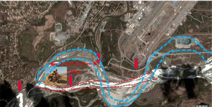
April 2010 satellite image of Tanana River channel with subsequent channel changes marked on it.
Notes:
Tanana River’s channel past the junction of Chena River as of 2010 shown by dashed red lines. Blue dashed lines show the historical main channel flow.
By spring and fall low-water stages in 2011, Chena River water flowed unaugmented by silty Tanana River water all the way to the bluff at “Judge Hepp’s house.” Implications for navigability are that the relative trickle of Chena River water spreads out over several sills of shallows within the wide old main channel of the Tanana River for 1.5-miles downstream of Binkleys’ village (Riverboat Discovery landing site). Boating between the Chena River and Tanana River is extremely difficult, and could become impossible for progressively more of the open water season in future years.
This April 2010 image with its persistent river ice shows the straightening of the main Tanana River channel. It also highlights the consequences of channel changes. Changes: 1. Straightened east-west channel; 2. Traditional mouth of the Chena now largely silted in, often inaccessible from the Tanana; 3. Island at upstream end of Perkins Slough almost gone; 4. U.S. Army Corps of Engineers' groins have played an unknown role in effecting channel changes and affecting groundwater flow in winter; 5. ATVs now reaching Byers Island after coming in via the Airport Loop Road. Could the airport’s appetite for longer runways drive the Tanana River even farther away from Fairbanks?
Satellite image from the Geodata Center, Geophysical Institute, University of Alaska Fairbanks.